A walk through history in Arthur's Pass Village
The Arthur's Pass Historic Walk is a 1.5 hour journey around the village, it starts at Glasgow Bridge behind the Chapel of the Snows and takes in many of the notable landmarks in this historic settlement. The walk consists of a series of panels with photograph's of the area in earlier times and some information about the locations significance.
Following the stops on the Historic Walking Track
The Arthur's Pass Historic Walk was originally developed to interpret the
story of the village using historical photographs. As you walk to plaque 1, you
are skirting mountain-beech/tawhairauriki forest, which
cloaks this entire valley up to the bush line
 |
| Arthur's Pass National Park logo |
1. Glasgow Bridge
The main road once crossed Avalanche Creek here.
The old bridge can be seen on the plaque photo. The
numerous buildings shown, which were associated
with the railway and tunnel construction, have been
demolished.
 |
| Arthur's Pass Historic Walk: Glasgow Bridge |
The foundations of the original bridge
are still in place next to Glasgow Bridge, named after
Melville James Pitt Glasgow, a mountaineer who
was involved with the building of the Arthur’s Pass
Chapel of the Snows.
 |
| Glasgow Bridge site: note bridge support larger than current bridge |
Visitors are welcome to enter the
interdenominational chapel.
Just after the bridge, a short detour to the left leads to
a platform overlooking a waterfall on Avalanche Creek.
 |
| The lovely interdenominational church at Arthur's Pass Village |
 |
| View up Avalanche creek from inside the Arthur's Pass Chapel of the snows |
The waterfall is often floodlit at night. Notice how the
gap in the beech-forest canopy and the humidity from
the falls and stream allow a variety of stream side shrubs,
ferns and mosses to thrive here.
 |
| Arthur's Pass Chapel of the Snows from up the Millennial walk next to Avalanche Creek |
2. Brake’s store
Jack Brake was the first storekeeper in Arthur’s Pass
during the busy tunnel construction days. The YHA
hostel now occupies the original site of Brake’s store.
The store catered for most of the day-to-day needs of the tunnellers, their families and the travelling public. Meat,
groceries, hardware, medicines, coal, firearms, clothing
and postage stamps were among the goods sold.
 |
| Brakes Store site is now the home of the YHA hostel in Arthur's Pass Village, on the right of SH73 |
In 1942 Brake moved across to the site of the present day store and tearooms, originally a five-room railway
engineer’s house. Jack Brake’s son Brian achieved
international fame as a photographer.
 |
| The current Cafe and General Store in Arthur's Pass, once the site of Brakes second store |
3. Coberger’s shop
Oscar A Coberger came to Arthur’s Pass in 1928 as an
alpine guide. He established an alpine sports depot in
this building and provided equipment and service to trampers, climbers and skiers for about 50 years. This
building is now home to the
Wobbly Kea Café.
 |
| The plaque on the outside of Cobergers Shop: aka the Wobbly Kea Cafe |
 |
| Cobergers Shop is now the Wobbly Kea Cafe, Arthur's Pass |
Oscar brought with him from Germany an enthusiasm
for skiing, at a time when many visitors to Arthur’s Pass
were taking up the sport.
In 1929 the Christchurch Ski Club (now Temple Basin
Ski Club) was formed. Development of
Temple Basin
commenced in 1933 with the building of a hut. A ski tow,
one of the first in New Zealand, was installed in 1948.
 |
| Mt Temple with the ski-field to the right of the rounded slope from the Otira Valley |
 |
| Close-up of the buildings at the Temple Basin ski-field from Otira Valley |
4. Tunnellers’ cottages main street
Bealey Flat 1910
Tunnellers’ huts dating from 1908 still remain on
both sides of the main road. These originally unlined
dwellings were sold at the completion of the tunnel in
1923 and are now privately owned as holiday cottages.
 |
| Old tunnellers huts at the western edge of Arthur's Pass Village |
The large building on the left-hand side of the plaque
photo is the old schoolhouse, used during the tunnelling
days.
It is interesting to note the different names the village
has been called over the years—Camping Flat, McLean’s
Town, Bealey Flat, as well as Arthur’s Pass.
 |
| The old school building on the Arthur's Pass Historic Walk |
The walk to plaque 5 takes you through the car park for
the Devils Punchbowl Falls. Before you enter the beech
forest 100 m further on, look around you for clues to the
valley’s glacial past. Notice how the falls plunge out of a
hanging valley, and how the forested fronts of the ridges
are truncated and smoothed out.
 |
| Punchbowl Falls coming from a classic hanging valley |
5. Bealey Swing-bridge
The Arthur’s Pass area has been popular with sightseers
and visitors for a long time. The most popular walk is to
the Devils Punchbowl Falls (131 m). The present bridge is
the most recent of several used to take visitors to the falls.
Floods in the Bealey River have carried earlier bridges
away. In 1962 the flood waters washed away a cottage at
the back of the Chalet Restaurant.
 |
| Information board about the Bealey swing-bridge and Arthur Dobson |
 |
The fixed bridge crossing the Bealey River, Arthur's Pass Historic Walk
|
The increasing use of Arthur’s Pass, especially at the time
of the first train excursions around 1924, coincided with
damage to the native vegetation by enthusiastic plant
gatherers. Botanist Leonard Cockayne led a campaign
to set aside land around Arthur’s Pass for National Park
purposes in 1901. Concerned people pressured the
government to further protect and reserve the land. In 1929, 48,600 hectares (120,000 acres) were gazetted as
national park. Progressive additions have been made
and the park now covers 114,839 hectares (283,652
acres).
6. Punchbowl power-station site
This is the site of the power house which was built in
1909 to generate electricity for the construction of the
rail tunnel. Power was needed for lighting, ventilation,
air compressors, and for pumping water out of the
tunnel.
 |
Turn off too the old power station for the Arthur's Pass Historic Walk
|
 |
| A long view of the whole Otira tunnel power station site, Arthur's Pass Historic Walk |
 |
Arthur's Pass Historic Walk: the plaque for the old power station
|
The concrete foundations were for generators driven by
Pelton wheels. The water to drive the wheels was piped
from the top of Devils Punchbowl Falls through tunnels
and pen-stocks down the steep hill next to the falls.
 |
Arthur's Pass Historic Walk: base foundation for the Pelton wheels at the power station
|
 |
| Arthur's Pass Historic Walk: base foundation for the Pelton wheels at the power station site |
Part
of the pipe line and tunnel can still be seen 20 minutes
up Mt Aicken Track. The power house was removed
in 1929.
7. Avalanche Creek and main road
Arthur’s Pass 1917
An interesting comparison can be made between the
main road in 1917 and today. The road level has been
raised and most of the tunnel workers’ huts removed,
but some, on the right-hand side, remain.
Part of the large building on the left-hand side was
originally a dining hall for unmarried tunnel and
railway workers.
 |
| Avalanche Creek running down towards SH73 through Arthur's Pass |
Guy Butler bought it and enlarged
it by adding part of the old Otira Schoolhouse before
opening it as a guest house in 1923. In 1969 the
building was developed as an
Outdoor Education Centre for use by school groups.
 |
| Arthur's Pass Historic Walk: the Outdoor Education Centre |
8. Arthur’s Pass to Otira rail tunnel
The tunnel is 8.5 km long and is on a gradient down
to Otira of 1 in 33, a fall of 278 m. It was drilled from
both sides, the first shot being fired from the Otira
end in 1908. When the two headings met in 1918, the
alignment and levels were accurate to within 3 cm.
 |
| Arthur's Pass Historic Walk: the plaque near the Otira Tunnel entrance |
 |
| Rail bridge over the Bealey River, Otira Tunnel opening |
World War I, contract problems, high labour turnover
and harsh weather conditions meant that the tunnel did
not open for rail traffic until 1923.
 |
| Close view of the Otira Tunnel portal, Arthur's Pass Historic Walk |
The turntable nearby was built to replace the original
one near the engine shed. It had to be long enough
to take the large Kb-class steam locomotives. These
were, in their day, the most powerful locomotives in New
Zealand.
 |
| The locomotive turntable at Arthur's Pass rail yards |
 |
| One of the old steam locomotives on a run to Arthur's Pass back in 2016 |
9. Arthur Pass Railway Station
The first railway station complete with refreshments and
dining rooms was constructed in Arthur’s Pass when the
line reached here from Springfield in 1915. Two brass plaques at the station were among those
placed by the Institute of Professional Engineers of New
Zealand to mark 150 years of New Zealand engineering.
They commemorate the construction of the Midland
Line and the drilling of the Otira Tunnel.
 |
| Arthur's Pass Historic Walk: the Arthur's Pass train station |
The present
station was built in 1966 to replace the previous one
which burnt down. Steam trains were replaced by diesel
locomotives in the late 1960's.
 |
| Historic walk plaque on the outside of the Arthur's Pass train station |
 |
| National Park sign at Arthur's Pass rail station, Mt Bealey/Avalanche Peak in background |
An historical
mural inside the waiting room, depicting attractions
along the highway, should not be missed.
The railway yards were built up with spoil excavated
from the tunnel. The subway floor is on the original level
of the yards.
 |
| Arthur's Pass train station...the mural they are talking about |
 |
| Painting of an electric train leaving Otira Tunnel, Arthur's Pass train station |
 |
| Painting of prospectors in the Otira Gorge, Arthur's Pass Railway station |
10. Arthur’s Pass to Otira coaching link
Before the advent of the railway, the 274 km horse-drawn
coach journey from Christchurch to Hokitika took 36
hours, including an overnight stop at Bealey. As the
railway advanced eastward and westward, coaches
transported passengers between the rail-heads, over
Arthur’s Pass, until the tunnel was opened in 1923.
 |
| Arthur's Pass Historic Walk: the coaching link plaque |
This
trip was exhilarating, sometimes dangerous, and the
weather was often miserable.
The Cobb and Co-type mail coaches were licensed to
carry up to 17 passengers. On steep sections of the road,
passengers were asked to assist the horses by getting out
of the coach and walking. The average working life of a
horse on this section of road was 18 months. Accounts
of accidents are common but there were remarkably
few fatal incidents during the 57 years that the coaches
linked Canterbury and Westland.
 |
| The Coaching links plaque outside the Arthur's Pass railway station |
You can see one of the
original coaches at the Arthur’s Pass Visitor Centre.
On the knob just to the south of this plaque are the
remains of one of the concrete ‘monuments’ from which
surveying for the tunnel was done.
 |
| The Cob and Co stage coach in the Arthur's Pass Visitors Centre |
11. Warden of the Snows
Appointed to Arthur’s Pass in 1950 as one of the first full time professional rangers in the country, Ray Cleland set
new standards in conservation and recreation.
Ray made the park more accessible and enjoyable for
visitors, creating the Bridal Veil Track, and building
six back-country huts. He was
instrumental in the development
of the 48-bunk youth hostel
and the Chapel of the Snows.
 |
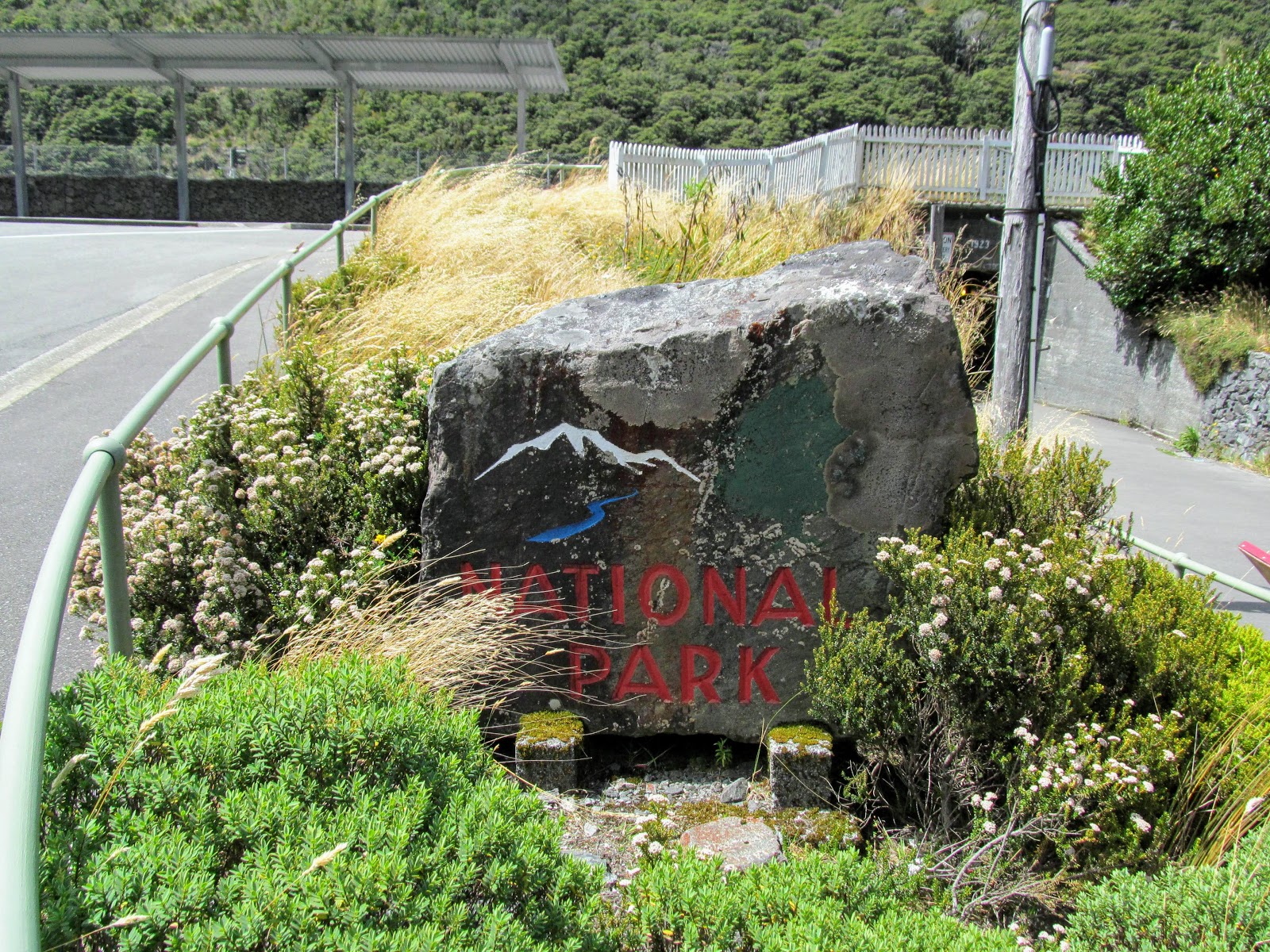
| Photo of Ray Cleland working on the National Park stone, Arthur's Pass |
 |
| Ray Clelands stone marker next to the Arthur's Pass railway subway |
He shared his passion
for nature with the park
visitors, creating an alpine
garden and giving evening
talks.
In 1958 he became supervisor
of all national parks—a leader
whose influence is still felt today.
Ray’s rock has been resurrected in Arthur’s Pass to
acknowledge his contribution to the management of our
national parks.